1.1 Project Background
Students that enrol in Mechanical-Aeronautical courses involve themselves to know more about the element of flight research. Aerospace flight is included in this category of flying. The students also will be required to enrol in a course, Aircraft Design. This course provides a thorough understanding of the ideas and procedures involved in aircraft designing. All of the principles of aerodynamics, propulsion systems, materials, and structural design will be learned in this course theoretically and practically. Wing design, fuselage construction, landing gear systems, and avionics systems are also among the topics that will be covered by students. The hands-on projects, computer-aided design (CAD) exercises, and exposure to industry-standard tools are frequently included in the curriculum too. Overall, the Aircraft Design course provides Mechanical-Aeronautical students with the information and abilities necessary to contribute to the creation of creative and efficient aircraft designs in the aerospace industry.
Malaysia’s tourism business is a thriving and diverse industry, with a wide range of attractions catering to a variety of interests. Malaysia is well known for its cultural diversity, and it is also home to many iconic landmarks such as Petronas Twin Tower, historical sites in Malacca City, vibrant street life in Kuala Lumpur, the country’s natural beauty portrayed in places like Langkawi for its clean beaches and leafy landscapes, and also Taman Negara, one of the world’s oldest rainforests. Furthermore, scrolling through the UNESCO webpage, stated there Malaysia owns four (4) sites nominated in the World Heritage List which are, Gunung Mulu National Park and Kinabalu Park, listed in the year of 2000, Historic Cities of the Straits of Malacca (Malacca and GeorgeTown), listed during 2008 and Archaeological Heritage of the Lenggong Valley, listed on 2012. Reported by The Star, Dato’ Dr Ammar Abd. Ghapar, General Director of Tourism Malaysia said that Malaysia would surpass the target of visitors from 16.1 million to roughly 18 millions (“To surpass foreign tourist”, 2023). However, after the pandemic era, Malaysia’s tourism industry experienced a flop in terms of figures where the tourists numbers skyrocketed from 26.1 millions to 0.13 millions (Ganesan, 2023). In the same article, Dato’ Seri Anwar Ibrahim, 10th Prime Minister of Malaysia, said that the Visit Malaysia Year will be postponed to 2026. This is one of the ways to give the tourism stakeholders some time for preparation after some failures arised due to the pandemic era.
Economic stability is a great indicator for measuring the performance of a nation because it reflects a country’s capacity to deal with economic setbacks, create sustainable growth, and offer a better quality of life for its citizens. The tourism sector serves as the primary source of income for the country, hence it contributes to the overall economic development of the country. According to the statistical data published by “Tourism Malaysia 2021”, there is a consistent upward trend between 2008 and 2019 which is from 49.6 billion Ringgit Malaysia to 86.1 billion Ringgit Malaysia. Reported by The New Strait Times, Department of Statistics Malaysia has published that during the first quarter of 2023, Malaysia has experienced a significant growth in domestic tourism and success attracting 48.6 million tourists which shows an increase of 33.7% in comparison to the corresponding period of the previous year. The largest contributor to the total expenses is shopping, which makes up 38.9% ,with food and beverage following with 15.2% and the purchase of automotive fuel accounting for 13.8% ( “ Domestic tourism jumped almost 34 percent in 1Q 2023”, 2023). Hence, the tourism activity can generate greater collection of taxes and revenues which will increase the nation's income.
In the 2023, Drone Readiness Index (DRI), Malaysia’s drone industry was ranked as the top one for Southeast Asia. The CEO of the MRANTI states that the implementation of drone technology will impact the Gross Domestic Product (GDP) by means of enhancing productivity, improving yields and reducing cost with a particular focus on sectors such as construction, agriculture and services (Abu Bakar D. , 2023). Reported by The New Straits Times, Datuk Seri Ahmad Maslan said that it is expected that the drone sector in Malaysia will attain a market value of RM 12.13 billion this year, representing 4.3% of the worldwide market share. Numerous drone services companies such as Aerodyne, Meraque and Aonic which are ranked among the best in the world in terms of scale, growth, financing and visibility that contribute to the development of the drone industry in Malaysia. Hence, due to the demand, the presence of successful companies and the development of talent, Malaysia has achieved an advantageous position within the global drone industry. This initiative will significantly enhance Malaysia’s drone industry leading to potential future in industries such as agriculture, telecommunications and oil and gas.
1.2 Problem Statement
The current situation of tourism in Malaysia is distinguished by a significant difference in the availability of aerial sightseeing opportunities. Helicopter rides are the most popular way for travellers to discover beautiful areas like Langkawi, as demonstrated by HeliOutpost Sdn Bhd's "Cenang Heli Joyride." However, these helicopter services are extremely expensive, with packages such as the "Cenang Heli Joyride" costing RM498 for only 5-6 minutes of exploring. This high cost provides a financial barrier, limiting the ability of the majority of tourists, particularly those on a tight budget, to enjoy the compelling beauty of Malaysia's landscapes from the air. Furthermore, other available solutions, such as quadcopter drones designed for tourism, are prohibitively expensive. These quadcopter drones require an enormous amount of power for lift and control, resulting in high operating costs. As a result, the overall cost of using quadcopter drones for tourism becomes outrageously expensive, worsening the affordability problem for travellers. The main problem in Malaysia's tourism scene is the unreasonably high cost of these aerial tourism options, which are driven by high operational costs, particularly fuel consumption for helicopters and power demands for quadcopter drones. This financial barrier effectively prevents a large percentage of potential visitors from participating in these airborne adventures, particularly those who emphasise affordability. The short duration of these rides adds to the problem by providing just short glances of the visual beauties, leaving tourists wishing for longer experiences. Furthermore, the current tourist scene fails to meet the improving expectations of modern travellers, who demand active participation and personalised exploration rather than passive observation, at a reasonable price. The lack of affordable and lengthy aerial sightseeing choices limits travellers' capacity to adapt their experiences to their choices, limiting them from fulfilling their trip dreams. This existing issue highlights the important need for an all-inclusive and cost-effective solution that allows tourists to experience a more extensive and specialised airborne exploration of Malaysia's stunning sites at a more reasonable price. To address these difficulties, aerial tourism must be reimagined, making it more accessible, inexpensive, and customised to meet the highlighting demand of travellers which is cost-effectiveness.
As stated by Hannah et al. (2015), environmental aspect can be defined as an element of an organisation’s activities or products or services that interacts or can interact with the environment. As we know the existing solution for tourists to get an experience in exploring the world is by using the helicopter and glider services. It is widely recognised that the existing services by which tourists presently engage with the unspoiled natural beauty of Langkawi are through the use of glider and helicopter services. Nevertheless, it is critical to recognise that these conventional services are conflicting with environmentally friendly concepts frequently resulting in several types of problems. Specifically culpable for these problems are air and noise pollution. The current issue arises due to the dependence on fuel for operating helicopters and gliders, which consequently leads to the release of unsafe gases such as nitrogen oxides and carbon dioxide. These emissions are responsible for the increase of the greenhouse effect, resulting in a negative phenomenon that impacts the Earth's atmosphere. This statement is also supported by Bejanaro et al. (2011) where they state that environmental concerns linked to rotorcraft operations have intensified with the anticipated expansion of air traffic. While helicopter activities constitute a relatively small portion of overall greenhouse gas emissions attributed to human endeavours, they are recognized as a primary contributor to localised air pollution in proximity to airports and urban regions. Additionally, noise pollution necessitates serious consideration. This is due to the impulsive vibrations from ‘blade slap’ making listeners perceive helicopters to be almost twice as loud as they actually are. The propeller engines utilised by helicopters and gliders produce an exceptionally high noise level while in flight. This occurrence not only disturbs the peace and privacy of human environments but also presents significant risks to the natural environment, affecting both ecosystems and wildlife. As stated by Goodwin M. (2020), Noise pollution can have both direct and indirect effects on physical health. In severe cases, exposure to loud sounds can directly lead to hearing impairment, including abnormal loudness perception, tinnitus (persistent high-pitched ringing in the ears), and distorted hearing. In addition, several studies have shown that noise pollution can also indirectly impact health. Short-term exposure to noise pollution may temporarily raise blood pressure and increase blood viscosity. Long-term exposure is associated with higher rates of cardiovascular disease, possibly due to its impact on stress hormone levels and the nervous system. To conclude the point above, there are several ways in which we can implement environmental principles into our actions. The use of battery-powered drones is a highly effective solution to pollution issues in which moving in a secure approach rather than relying on fossil fuel.
The safety aspects of operating a helicopter bring out many downfalls in both technical and natural aspects. According to Slavov & Nedelchev (2023), The key criteria that influence the effectiveness of aviation systems and the provision of flight safety are the dependability of a human operator and his timely professional judgements. Human error in this aspect is one of the main reasons for air disasters. Humans naturally tend to differ in reaction speed and often hone their skills in flying and controlling aircraft based on muscle memory. Generally, in steady conditions the human brain does not need to process many tiresome manoeuvrings to stabilise the aircraft. However, at less than normal standards, humans overlook certain safety pitting and neglect many safety factors such as thrust adjustments on extreme gusts. This soon relates to a disaster with losing control and having to input a lot of strain on control surfaces to regain stability. And with the natural strain and fatigue in the airframe and control surfaces, this soon leads to disaster. Additionally, workmanship and engineering flaws during the production play a major role in the failure of aircraft in general (De voogt, 2018). Miscalculations in loading at different weather conditions can strongly affect the manoeuvrability and stability of the aircraft. As helicopters do not have extendable control surfaces unlike regular aircraft, the precision in the design aspect can strongly affect the disastrous outcomes of the aircraft and its general structure. Furthermore, inaccuracies in the loading capacity can cause an imbalance in the aircraft that will often lead to accidents. While it is common to account for these by having stringent inspections and supervision, The internal flaws and impurities in the structural material can often be overlooked. It is very uncommon to find 100% pure metals. The little impurities in the metal can often create crevices that lead to fracture and failures in the airframe and the skeleton of the entire craft. Furthermore, certain composite materials have temperature dependent behaviour and overshooting these limits can cause premature wear and tear that often can be overlooked by maintenance. These factors can all add up to premature disasters even with minimal piloting errors and close to nonhuman intervention.
Finally, transportation issues also play a major obstacle in using conventional sightseeing methods. The cheaper alternative for the helicopter tour is to go by boat and this usually takes longer and is more tiresome. Some tourists may get sea sick while others will get travel fatigue from the rowing or paddling motion of the boat. Furthermore, the sightseeing experience is short lived since the distance and the places that can be covered in a short period of time is much lesser than a helicopter or aircraft tour due to the immensely low travelling speeds. Then adding to the current set of challenges, there is another significant transportation issue, that some people cannot sit by boat especially to certain islands, it can be a real puzzle. Some islands pose a bit of a challenge such as shallow waters, rocky shores, or not enough good places to dock. The boat routes we do have might not be the most straightforward, making travel times longer and involving more transfers, that’s not exactly what a typical tourist might have in mind. In addition, the traditional boat engines are causing more problems than solutions, they are contributing to water pollution and generating a racket that disturbs marine life and the peaceful ambiance of the island's tranquil environment. This not only limits the tourist from exploring all the fantastic islands Malaysia has to offer but also raises some serious environmental red flags. Tackling these boat transportation hurdles is crucial for creating a travel experience that lets everyone explore the island while keeping a friendly eye on the environment.
1.3 Project Objective
The research objectives are basically being derived from the key problem areas as a response to a variety of challenges. The problem includes the safety concerns, environmental issues and also the costing. Thus, the aforementioned issues drove us to develop precise objectives to ensure that the drone will not encounter the same issue in the future.
First and foremost, this drone project will basically want to ensure the drone operation follows airworthiness regulations, especially about international borders in Langkawi. Although Langkawi itself falls within Malaysian territory, its close proximity to the maritime border with Thailand requires operators to secure the necessary permissions, considering specific airworthiness standards near the international boundary in Langkawi. These standards encompass various aspects including the design, construction and operational procedures of drones. Drone operators must be vigilant about security concerns, potentially requiring additional clearances and adherence to specific protocols to mitigate risk effectively. These operations are limited to Class G airspace where all drone operations must be carried out at a minimum distance of 9.26 kilometres away from aerodromes. However, drones commonly operate within a 30 m range of individuals during takeoff and landing, facilitating precise control and monitoring by operators. This close proximity is designed to minimise the potential for collisions and accidents, adhering to safety guidelines and regulations to safeguard people and property during these crucial phases of flight.
Next, this project intends to design a drone that is safe and complies with regulations of UAV. These standards primarily focus on addressing safety and the environmental concerns, as well as the possibility of human error. According to the findings of P.J.M. et al. (2014), it is of the utmost importance to promote the responsible usage of drones, with the primary focus being on the assurance of safety. In regard to this, the safety features that we are aiming to incorporate into this drone include the addition of components such as an ultrasonic sensor. This sensor serves as a crucial element which is basically for being an obstacle identification. This aligns seamlessly with the research by Figliozzi et al. (2016), where the correlation between safety and efficiency in drone operations is an important factor. It emphasises that effective design and operation are crucial for reducing the likelihood of accidents and collisions. By adhering to these opinions, we want to design a drone that not only complies with safety regulations but stands out by prioritising safety through advanced features, which later ensures a secure and dependable experience, particularly in the tourism industry. In a specific way, this drone aims to contribute to a safer and more enjoyable experience for tourists which can foster a sense of confidence and trust to utilise our drone.
Last but not least, since this project focuses on building drones for tourism, this project is also determined to provide tourists a sightseeing experience using UAV by transferring real time video captured by UAV and ensuring fast precision of video transmission by using video transmitter devices. According to the research by Ilkhanizadeh et al. (2020), the idea of employing drones for taking videos and pictures, basically could enhance destination marketing by presenting distinctive viewpoints of popular tourist destinations. So, our target is to basically introduce the technology breakthrough in the tourism industry at the same time in order to simultaneously give immersive, high-definition visuals of monuments and scenic views rather than spending money to pay for helicopters. In light of this, these ideas will be linked to SDG 9 (Industry, Innovation, and Infrastructure) and SDG 11 (Sustainable Cities and Communities). This is due to the fact that this project will, in essence, be an innovation in the tourism industry, particularly in terms of providing customers with the best possible opportunity to view places of interest. Then, by doing so, it will improve infrastructure, promote sustainable tourism, and contribute to the SDG by encouraging innovation and providing tourism experiences that are eco-friendly and community-centred.
1.4 Project Scope
1.4.1 Drone Expected Altitude
Our project “Horizon Hawk” is designed to reach an altitude of 50 m above ground level. This is due to several reasons. To get a greater view of the whole beach and ocean, our drone is expected to be able to fly 50 m above the beaches of Langkawi Island and wander around. According to the CAAM, our UAV is under the category low-risk drone operations thus the type of approval we will get is ATF which only allows our project to fly less than 400 ft AGL which is 122 m above ground level (Admin, 2023) . This height is sufficient for users to fly our UAV for viewing the beautiful islands and oceans of Langkawi Island. Furthermore, our drone is designed to reach an altitude of 50 m because it will help the UAV to less likely run into obstacles such as trees and buildings. When the user is controlling the UAV, it might run into obstacles like trees or buildings. If our UAV is able to fly at an altitude of 50 m, the risk of running into obstacles will be greatly reduced. Other than that, it will help UAV to avoid obstacles by flying over the trees or mountains to dodge them and avoid damage to our UAV. Moreover, this altitude provides a great balance between capturing a wide view and also ensuring the image remains clear. Flying higher will reduce the visibility for sightseeing and the experience of the users will be affected overall. Therefore, our project will be designed to operate within 50 m, focusing on providing great sightseeing experience in Langkawi Island but still ensuring the image captures are still clear.
1.4.2 Take-Off Point
Take-off point of this drone needs to be considered due to the spaces available for drone launch. Considering the airspace available and the border of Malaysia with Thailand. The drone is expected to have its optimal take-off point at Tanjung Rhu Beach and fly towards nearby islands which are Pulau Kelam Baya and Pulau Chabang then return back to Tanjung Rhu Beach for landing. An area of 92,000 m2 will be set as a barricade for our UAV to fly within it and the total distance for the flight path will be 1.69 km. The barricaded area for the drone take-off point would be an area around 1,000 m² and the distance from the crowd is 90 m or beyond to ensure the safety of the tourist around the beach area. The area is barricaded so that the tourist would not go across the landing or take-off zone by mistake. Located on the beach, specifically on the coordinate of 6°27'25"N 99°49'26"E is chosen to be the perfect spot for the drone to take-off and landing. The area that we chose as a take-off point is privately owned by the resort close by. Thus, the place could be rented or we need to ask for permission from the resort management. This area is chosen due to the specific criteria that it meets, including the proximity to tourist attractions, distance from the nearest airport and the compliance with the airspace regulations of Malaysia. Take-off point for the drone needed to be spaced between the border and the airspace for the international airport. The Langkawi International Airport is considered as a controlled airspace where based on the regulations of CAAM, the distance for a safe launching of the drone is beyond 5 miles or 9.26 km in distance. Distances to the border are needed to be considered also. Other than that, compliance with the border airspace is man26datory due to the drone usage of cameras which are considered as surveillance drones. To adhere to national law, the northern part of the island is considered as unpreferable due to its close proximity with the border. Tanjung Rhu Beach area is preferable as our take-off point as it has two islands nearby with beautiful scenery. Moreover, the area is also 20.5km away from the Langkawi International Airport which allows our UAV to operate in this zone.
Figure 1.1 Take off/landing point
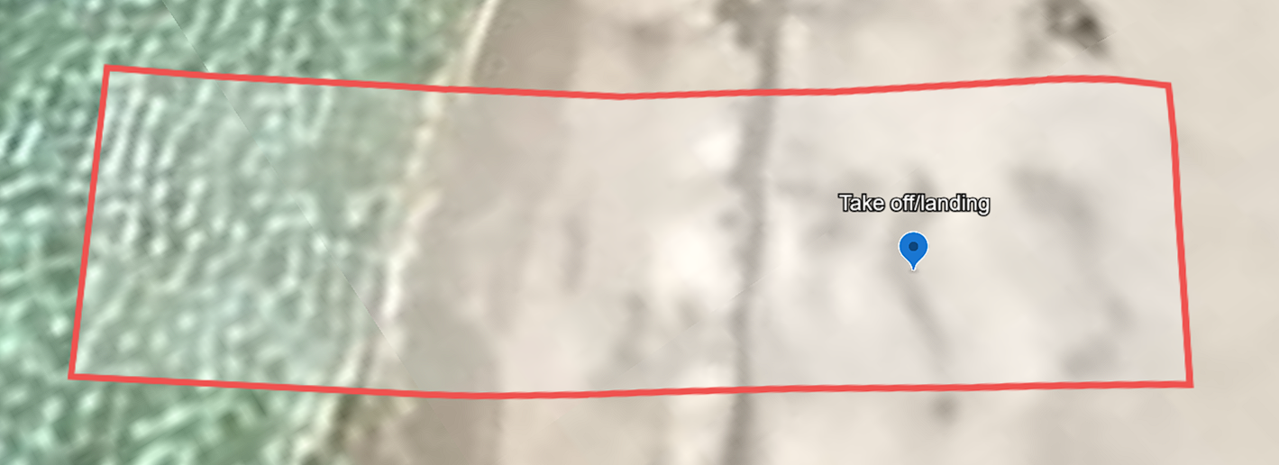
Figure 1.2 Barricaded area
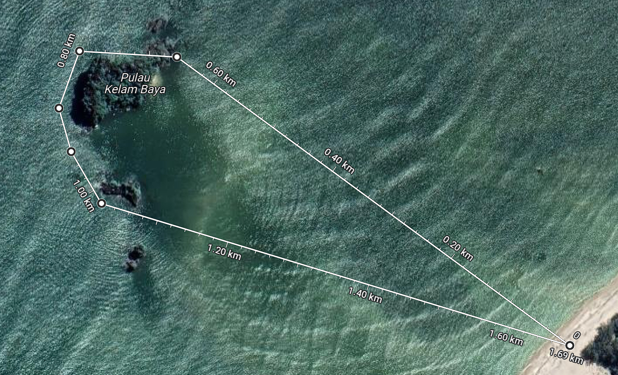
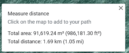
Figure 1.3 Flight Path
1.4.3 Camera Specifications
The camera capturing visual information will be chosen according to its specification. First the camera must be compatible with a 3-axis stabilised gimbal as when UAV is flying it might have vibration and a gimbal can help to stabilise the camera and ensure the image captured is clear and sharp. The resolution of the camera is considered to be at an outstanding 6K resolution and 30 fps, or up to 60 fps at 1080p or 4K. The need for such high resolution becomes clear as the drone will operate at an altitude up to 50 m, avoiding possible obstacles. When the drone is needed to fly at a high altitude, then this approach ensures that the camera can perform the task with ease while still providing a seamless and high-quality streaming experience. Furthermore, due to our project objective which is to provide a sightseeing experience using UAV, a high resolution becomes more important to ensure users can see very clear images and if possible like real world experience. All these camera features mentioned above, work together to achieve the goal of providing extremely steady recordings with outstanding detail accuracy, ultimately ensuring customer satisfaction.
1.4.4 Drone Range & Endurance
The drones are designed to give the customer a real-time experience of a stunning view of Langkawi island. In that regard, for one flight, it is expected to take 1 hour. The duration of the flight takes into consideration a few factors, such as the time it takes for the UAV to take off and landing as the expected time taken for each operation is 6 minutes. The average speed of our drone is 54 km per hour, the duration for the drone to reach and come back to the launch point is expected to be 8 minutes each. Aside from that, another consideration is the battery capacities. Flying a drone consumes a lot of energy. Thus, our project is designed to use a battery that has a capacity that can last up to 1.5 hours, but for each operation, it is safer to keep it within 1 hour. The range of our project “Horizon Hawk '' will be designed to operate up to 50 km. This range allows our UAV to fly in the designated area for about 5 rounds. The flight to each round will take about 28 minutes with additional 10 minutes as buffer times, thus one hour of tour will be very sufficient for our UAV purpose .
One hour of flight is enough to give the customer a full tour of Tanjung Rhu Beach. They can fly the drone freely within the designated area of Tanjung Rhu Beach. On average, people would not spend too much time on one activity, as they would take their time to explore other activities as well. The one hour of flight can give customers the satisfaction of observing beautiful scenery and hidden gems of the Pantai Cenang. Even though it is an interesting activity, most people won't spend too much time looking at the screen to see the scenery. In order to have a stable income, the amount of time provided is sufficient, as the number of flight services provided can be more than one in one day. At the end of the day, it is not just able to give a real time experience to the customer but also be able to generate a good amount of income in order to maintain the business.


